
On a whim, I made a right turn off of US 93 and up Big Wash Road. Signs indicated camping and hiking areas, about which I knew nothing. With some daylight left, I went north down the wide, graded dirt road to fill in that gap in knowledge. After about five miles of flat desert, the road starts to climb Packsaddle Mountain.
Packsaddle Mountain looms over Chloride, Arizona, a not-quite-ghost mining settlement northwest of Kingman AZ. The mountain is on the southern edge of the Cerbat Mountains, just southeast of the Mount Trimble Wilderness Area.

The road abuts the wilderness areas for about four miles. There are no signs or formal pull-outs – you’d have to locate yourself on the map and find a place to park. But poking around wilderness areas requires that level of self-sufficiency at a minimum. Mt Trimbul Wilderness has little water and zero services, but it does have a lot of elevation change. I had a couple of hours, not a couple of days, so I stayed on the road.
Big Wash Road, from this direction, remains wide and well-graded. You will appreciate high clearance, but you could get a passenger vehicle up as far as the trailhead (see below) with caution and nerves. You’d be hard pressed to get a trailer of any size up here.

At the top of the first good climb, about 8.7 miles in, I found Packsaddle Campground, which is marked by a vault toilet and an unlisted number of dispersed campsites. At 6000’ – the median elevation of the ridge that separated the “peaks” of Packsaddle – the site is a good 200 F cooler than the desert floor below. There is trash service here, but no water.
There are no facilities with water until you get to Chloride – and even then, something would have to be open.


I kept going along the ridgetop until just past the 10 mile mark, where I found the turn-off for Windy Point Campground.
Windy Point is a BLM fee area ($8/night, on the envelope and trust system). The fee, I suppose, is justified by the addition of picnic benches and fire rings, and even more spectacular views of the surrounding countryside than the campground just yonder.

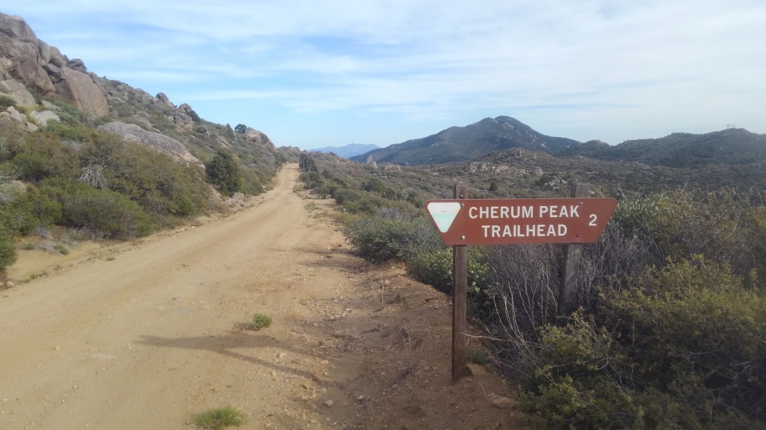
Big Wash plows farther, past this turn-off, towards the marked trailhead for Cherum Peak trailhead, some two miles past Windy Point. The Cherum Peak Trail is three miles one way, climbing a thousand feet to the top of the peak it is named for – the highest point in the southern Cerbat Mountains. The views are reportedly rewarding. I had an hour of sunlight left, and passed on hiking it that day.
Important: This is the turn-around if you do not have a high clearance vehicle and/or wish to have a pleasant, relaxing drive back down to pavement.
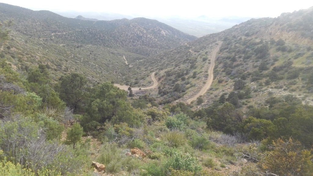

I went forward – down the mountain on the eastern half of Big Wash “Road”. And while my Subaru Forester was up for it, she was just barely up for it, and this was downhill in the clear, dry afternoon. I would want no part of this in the dark or the rain. You will want a 4WD to go up from this direction.
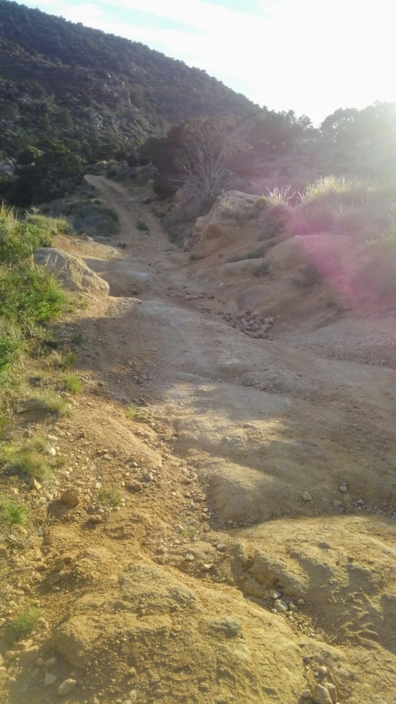
Past the trailhead, the road beyond is rough, alternating from deeply rutted to a lightly graded landslide. To weave around the rocks and the ruts Ruby (the Subaru) was often obliged to make close friends with the brush crowding the side of the now narrow jeep trail.
Friends, I took this route slow enough that bugs buzzed around my car. I spent the better part of an hour traversing a mere six miles. The gate, and the mining ruins just beyond are just past the halfway point of the ugly part. I made it through with only a couple of sickening crunches, and only one part where I seriously feared I would tip the vehicle.
Around the 16 mile mark, the road dumps into the wider, more civilized Mural Road, so named for the murals that cover some large rocks on the side of the road.
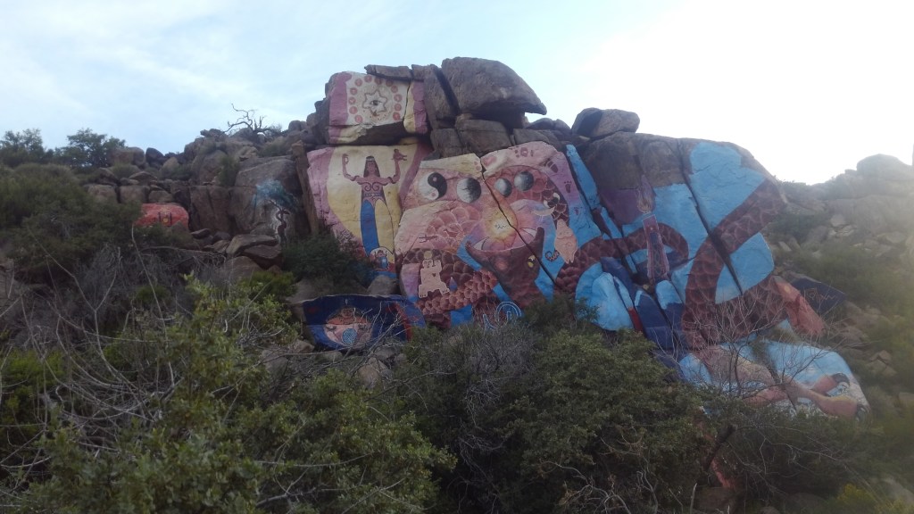
These are the Roy Purcel Murals – and not graffitti – but Art, and the sort of roadside attraction that Route 66 was once famous for. Roy Purcell took a break from pursuing his master’s degree in fine arts to work some nearby mines. While there, circa 1966, he painted The Journey, this 2000 square foot wonder of color and imagery.
My photo suffers from the setting sun putting the rocks into shade. The website above has better ones.
While you check that out, I’ll pull Ruby over and make sure she isn’t hemorrhaging vital fluids.

She neither limped nor bled, so on I went.
Chloride was once a sprawling silver camp, and may be the oldest continuously inhabited mining settlement in the state. While it is a shell of its past, at about 350 residents, it is not a ghost town. It is not, in any way, bustling.
Mural Road dumps onto Tennessee Road – the main drag of Chloride, where I had to stop for local dogs, local people finishing their conversation in the roadway, and deer. In town limits I stopped to watch four deer cross the road.
Tennessee Road morphs into County 125, which takes you back to US 93.
